
Geophysical potential field investigation of the Macolod Corridor and adjacent regions: Crustal structure, heat flow, and deformation near the terminus of the Manila subduction zone
02 Jan 2024

The Macolod Corridor is a volcanic field encompassing the provinces of Cavity, Laguna, Batangas, Rizal, and Quezon. It has previously been identified as a rift zone running perpendicular to the chain of active volcanoes associated with the Luzon Arc. To determine the distribution of rocks and geologic structures beneath the ground, gravity and magnetic surveys were conducted. Anomalies in the gravity and magnetic fields point to the complex occurrence of rock units and the variability in their density and magnetization. The new datasets obtained from the recent geophysical surveys are assimilated with existing geophysical data to come up with gravity and magnetic anomaly maps of the study area. Through data inversion and modeling, 2D pictures of the Macolod Corridor were generated.
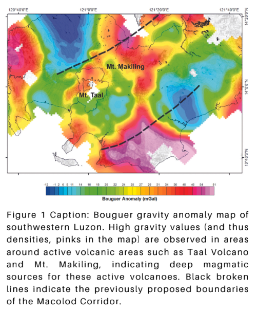
The tectonic decompression expected of a volcanic rift manifested as a series of faults accommodating the opening of the Corridor is deduced from the gravity and magnetic anomalies. The opening of the rift is also consistent with the influx of magma from beneath, creating an extensive volcanic field in southwestern Luzon. The active volcanoes are in fact characterized by positive gravity anomalies, indicating deep sources of the lava being erupted in these localities (Figure 1).
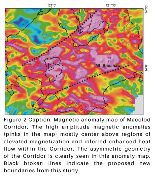
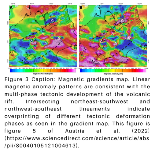
Differential motions in the Sibu-Verde Passage Fault in the southwest and the Philippine Fault in the northeast are also expressed by the asymmetry of the Macolod Corridor. The southwest part of the Macolod Corridor near Taal Volcano is significantly narrower compared to the northeast near Mt. Banahaw. This pattern is clearly seen in the magnetic anomaly map of the region (Figure 2). Linear anomalies in the gravity and magnetic field also point to intersecting faults and fracture zones. These are significant in consideration of geothermal processes and the ascent of magma and potentially mineral-rich fluids towards the surface. In our 2022 Tectonophysics paper, we point out the role of past tectonic phases in the development of these fracture patterns. Intersections of these breaks and cracks in the rocks can be the focus of fluid movements and can be vectors in geothermal and metal mineralization explorations. These linear anomalies are concentrated within the Macolod Corridor and may point to localities where a high probability of active geothermal systems and mineralization are to be found.
Project significance
A good understanding of the tectonic structure and geologic processes at play in a particular area is essential, especially in the assessment of natural hazards and resources. The Macolod Corridor has long been recognized as a volcanic field, but a complete picture of its crustal structure is yet to be achieved. Recognizing the economic importance of southwestern Luzon, it is imperative that active geologic structures (i.e., faults and volcanoes) be identified and assessed for potential hazards that they may pose to the region. To achieve sustainable growth and security of infrastructure and the local population, the geodynamics and tectonics of the Macolod Corridor need to be well understood. Cases in point are the most recent eruptions of Taal Volcano as well as moderate magnitude earthquakes in Batangas. The latter impacted not only southern Luzon but Metro Manila as well. The activity of faults both onshore and offshore of Macolod Corridor can potentially wreak havoc on the region. Magmatism is closely linked with geothermal processes in this rift zone. Being a volcanic field, the Macolod Corridor has vast potential for geothermal resources. In light of climate change and the search for viable indigenous green energy sources, it is worth looking into the geothermal systems (e.g., heat source, reservoir characteristics, fault systems, etc.) in the area.
Project Output
The research investigated the geophysical structure of southern Luzon, particularly the density distribution and magnetic characteristics of subsurface rocks. The research proposes a new boundary of the Macolod Corridor and the locus of rifting and associated magmatism, with rifting apparently proceeding from the northeast to the southwest near Taal Volcano. The research also produced a map of the Curie depths beneath the study area. This is particularly significant since the shallow Curie depths indicate high heat flow in the Macolod Corridor. Some of the results of the research are elaborated in the research article titled “Magnetic field characterization of Macolod Corridor (Luzon, Philippines): New perspectives on rifting in a volcanic arc setting” published in the ISI Tectonophysics Journal.
Collaborators
Dr. Carla B. Dimalanta and Mr. Rurik SP. Austria, National Institute of Geological Sciences, College of Science, University of the Philippines, Diliman
Graciano P. Yumul, Jr., Cordillera Exploration Co., Inc., Bonifacio Global City, Taguig City, Philippines
